

Açıklarmısınız bunları
Veri Paylaşımı, Değerlendirme, Analizler
-
-
-- Güncel ao nao pna mjo indexi
The content cannot be displayed because you do not have authorisation to view this content. The content cannot be displayed because you do not have authorisation to view this content. The content cannot be displayed because you do not have authorisation to view this content. The content cannot be displayed because you do not have authorisation to view this content. -
endeksler güzele dönüyor
-
Güncel Endeksleri Beğenmedim 😉😉
-
Stratosferik Rüzgarlardada Rekor Düşüler Var Mart Başında
The content cannot be displayed because you do not have authorisation to view this content. -
- Resmi Gönderi
Ülkemiz yarın öğleden sonra uzun süreçli bir soğuk hava dalgasına maruz kalacak rakımı yüksek bölgeler çok yoğun kar yağışı rakımı düşük iller de ise kuvvetli yağmur görülecek bu patern yaklaşık 7-10 gün sürecek
-
Güncel ao Nao Pna Mjo endexi
The content cannot be displayed because you do not have authorisation to view this content. The content cannot be displayed because you do not have authorisation to view this content. .The content cannot be displayed because you do not have authorisation to view this content. The content cannot be displayed because you do not have authorisation to view this content. -
Açıklama
-
Gugulu görmeden kış bitmezdi bak gösterdi kendini namussuz :D
The content cannot be displayed because you do not have authorisation to view this content. -
Mjoyu atmaya gerek duymuyorum çünkü çembere girdi bu da modellerin kafasını karıştırdı o yüzden bu süreçte mjoyu takip etmek saçma olur ao nao pna endexi iyi geldi
AO: nötr meğelli
Nao: Nötr
Pna: negatif amerika kıtasıdnaki basınç dizlimini gösterir diye biliyorum pnayı ve negatif olunca ülkemize yarıyor diye biliyorum yanlışsam hocalarım düzeltsin.
The content cannot be displayed because you do not have authorisation to view this content. The content cannot be displayed because you do not have authorisation to view this content. The content cannot be displayed because you do not have authorisation to view this content. -
Polar vortex 5 6 dan sonra tekrar güçleniyor 10mart itibariyle 30ms düşüşe geçiyor güzel şeyler bizi bekliyor allahın izniyle kışı kapatmak şu vakitte çok saçma olur.
-
The content cannot be displayed because you do not have authorisation to view this content. -
- Resmi Gönderi
Bölgesel rüzgarlarin öngörüsü 10m/s şu anlık bu değerler 0 ve altına inerse Avrupa yararlanır inmezse biz
-
- Resmi Gönderi
Hasan61 iyidir
-
- Resmi Gönderi

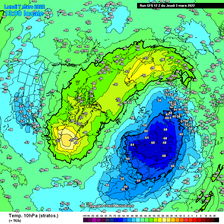


Çoğu kişinin artık farkına vardığı mart 2.hafta içerisinde gözüken sistem için veri analizi yapalım.
10HPA (5500metre) yüksekliğinde bölgesel rüzgarlarda düşüş mevcut bu sayede kutup girdabı dağılıyor kutup girdabı dagılması demek soğukların güney enlemlere atak yapması demektir.
Türkiye bu sistemden ne kadar etkilenir,en çok neresi etkilenecek ? sorusunun cevabına bakalım.
Şimdi şöyle bir kararsızlık mevcut birçok senaryo soğukların yatay hareket ile atlantik siklonlarına uzanmasını öngörüyor,bir diğer mevzu ise atlantik siklonlarının yerine iskandinav bölgesine kolunu uzatan azor desteği bu sayede soğuklar kuzeyimizden direk dalış yapabilir,bir diğer mevzu ise
 soğukların gücüne denizlerin sessiz kalmaması ve siklon rotasına göre soğukların yönünün belirleneceği.
Benim şahsi düşüncem en kötü ihtimalle kuzey kıyılar etkilenir.
Kafkas ihtimali yok.
-